


|
The 1700's
   
Settlement on Stanley Creek
Stanley, the town, got its name from Stanley Creek which as tradition says was named for a
prospector who panned for gold in that creek. His exact Christian name has not been ascertained but old
records indicate a John Stanley, a David Stanley, and
a George Stanley all lived within the vicinity.
John Stanley was granted land in this area which at that time lay in Anson County, described as
being on the East side of Kuykendall's Creek on 10 April 1761. However, he moved on farther south to
the State of Georgia, where he was living in September 1769 when an indenture was recorded in the Lincoln
County Court House between John Stanley and Bostian Best for a parcel of land that had been granted to
Mr. Stanley in December 1768. This land was identified as lying on both sides of Long Creek, bordering on
Routhes corner, Bennett's line and David Stanley's
line.
Another transaction in 1770 indicates that a George Stanley purchased a tract of land in Tryon
County in the province of North Carolina, being situated on Fishing Creek, joining the Indian Lands.
That land is now a part of South Carolina, but not too great a distance for him to come to this area to
prospect for gold. (It could have been one of these men for whom Stanley Creek was named.)
Originally the community of Stanley or Stanley Creek was located from the banks of Stanley
Creek on farther to the north, reaching to the Great Road or the Stagecoach Road. This settlement
location was undoubtedly for convenience to the ferries into Mecklenburg County and from there to points
farther south for going to market; this combined with the fact that all the first settlers made their homes as
close to the best source of water they could find. In addition to the many creeks and branches in the area,
they were situated near the Catawba River and even closer still to the largest creek, Dutchman's, which
flowed into the Catawba. At that time the area was
known as Stanley Creek Community. Earliest settlers in this area were the families of Abemathy,
Armstrong, Cloniger, Eddleman, Handsel, Hoffman, Leeper, Rankin, Rhyne, Rutledge, Seitz, Smith, Wills,
and others.

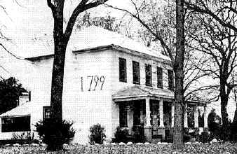 |
THOMAS RHYNE HOUSE
Brick home built in 1799 by Thomas Rhyne and his wife, Barbara. Located on Stanley-Lucia Road.
|
Thomas Rhyne and his wife Barbara, after arriving in Lincoln County, first
settled in the area near where Goshen Presbyterian Church was later built, in North
Belmont, NC. Barbara Wise, wife of
Thomas Rhyne, was the daughter of Frederick Wise and _____Warlick. She was born
sometime between 1755 and 1760.
It is believed that Thomas was born on 19 September 1745. While living in
York County, Pennsylvania, the father of Thomas, John Martin Rhein died at the age
of 40 on 5 Sept. 1758. Thomas was 13 years of age at that time and was bound out to a
person who was a saddlemaker, until Thomas reached the age of twenty one. While there he learned
what would become his trade when he settled in North Carolina.
30 He acquired much land over the years. His early holdings
might possibly be undeeded, however. Deed Book No. 2,
pages 569-570 in Lincoln County Court Records shows that on 7 January 1777
Thomas purchased 202 acres from Joseph Johnston on the waters of Kuykendahl's
Creek. Two grants were issued to him for 900 acres on the waters of Stanley's Creek
on 9 October 1783 and 1 November 1784.
This land connected to his original holdings and stretched from the Stanley Creek
area to North Belmont where Goshen Cemetery now stands. This apparently was the property on
which he built his fine brick home in 1799. The numbers, 1799,
are revealed on the side of the home which still stands today.
The home was passed on to the son, Daniel, and has continually been passed from one generation to
the next, always having as its occupants members of
the Rhyne family and descendants of Thomas and Barbara Wise Rhyne.
In 1988 the farm was recognized as a National Bicentennial Farm based on the fact that the land had
continuously been farmed for the past two hundred years while in the ownership of the same family for the
entire two hundred years. At the time of the award the home was occupied by Thomas' great-great grandson,
Richard Rhyne and his wife, Barbara Lowe Rhyne.
Found in the N. C. State Archives among the
estate papers of Alexander Brevard was a list of Continental Services or Militia in the late 1700's
and on it was the name of Thomas M. Rhine.
Most likely it was for this service in the
militia that Thomas was granted the land in 1783 and 1784.
Thomas Rhyne died in 1837 and Barbara died
sometime before 1830. Both are buried in the family
cemetery behind the 1799 house.
|
Settlement Along South Fork River and Hoyle's Creek
At the same time pioneers were settling along Dutchman and Stanley's Creek others were granted and
purchasing land on the other side of what would become the town of Stanley - along Hoyle's Creek near the
South Fork River. It was near here that Sebastian Best and Peter Hoyle, two of the very earliest
pioneers to the Catawba River Valley, made their homes. Those early Stanley settlers were from the
families of Moore, Smith, Lineberger, Shetley, Hovis, Cloninger, Nance, Stroup, Rutledge, McGinnis.
[ The Museum ] [ Contact Us ] [ Stanley History ] [ Photo Galleries ] [ Citizens ] [ Recollections ] [ Schools ] [ Churches ] [ Community ] [ Recent History ] [ Order the Books ] [ Topic Index ] [ Site Index ] [ Search ] [ Acknowledgments ] [ Related Links ] [ Guestbook ]
|
|